
For decades, electronic navigational charts have been central to modern maritime navigation. As the maritime sector becomes increasingly digital, however, the need for richer data, improved interoperability and more integrated decision-support tools is transforming how nautical information is produced, exchanged and used. At the heart of this evolution is S-100, the Universal Hydrographic Data Model developed under the International Hydrographic Organization (IHO).
More than a new standard for electronic charts, S-100 establishes a common framework for a broader ecosystem of digital hydrographic and maritime data products. Its purpose is to enable different types of information to work together more effectively, supporting safer navigation, improved situational awareness and more informed decisions at sea.
Beyond the Traditional Electronic Navigational Chart
Historically, electronic navigational charts (ENCs) have relied primarily on the S-57 standard. While S-57 has played a fundamental role in digital navigation, evolving operational requirements call for a more flexible framework capable of supporting a wider range of data types and applications.
S-100 addresses this need by providing a structured, extensible model for developing interoperable hydrographic products and services. It builds on internationally recognised geospatial standards, including those developed by ISO/TC 211, helping align maritime information with broader geospatial data infrastructures.
This evolution is particularly important as navigation systems increasingly need to account for more than chart features alone. Water levels, seabed depth, surface currents, marine protected areas and navigational warnings can all contribute to a more comprehensive understanding of the marine environment.
Rather than treating these datasets as separate sources of information, S-100 provides the foundations for bringing them together within a common digital framework.
Introduction to the S-100 framework and its associated Product Specifications under development.
How the S-100 Framework Works
S-100 is a framework from which individual product specifications are developed. Each specification defines how a particular category of information is structured, encoded, described and presented.
An important part of this approach is the use of standardised feature and portrayal catalogues, alongside metadata and data exchange mechanisms. These resources help ensure that information is consistently interpreted by compatible systems and that different products can be integrated without losing their intended meaning.
Interoperability also extends to how information is displayed. For example, surface current information should be presented in a way that does not obscure critical chart features such as depth soundings. Consistent rules for data representation help different information layers complement one another while preserving the clarity required for navigational decision-making.
The framework also supports more flexible data distribution. Depending on the service and its implementation, users can obtain the datasets and updates relevant to their needs, rather than necessarily downloading an entire collection of maritime information. This can be particularly valuable in environments where connectivity and bandwidth are limited.
To learn more about S-100 and the product specifications being developed within its framework, watch this introductory video from the International Hydrographic Organization (IHO).
A Growing Family of Digital Data Products
The S-100 framework supports a range of product specifications, each addressing a distinct aspect of the maritime environment. Together, they can provide a richer information base for navigation and other marine-related activities.
Some key examples include:
- S-101 – Electronic Navigational Chart: The next-generation ENC product specification, designed to succeed S-57-based ENCs within the transition to S-100-compatible navigation systems.
- S-102 – Bathymetric Surface: Provides gridded bathymetric information that can offer a detailed representation of seabed depths and underwater terrain.
- S-104 – Water Level Information for Surface Navigation: Supports the use of water-level information relevant to navigational planning.
- S-111 – Surface Currents: Provides standardised surface current information to support a better understanding of current conditions.
- S-122 – Marine Protected Areas: Represents information on designated marine protected areas.
- S-124 – Navigational Warnings: Supports the standardised exchange of navigational warning information.
- S-129 – Under Keel Clearance Management: Addresses information and functionality associated with managing the clearance between a vessel’s keel and the seabed.
These products are developed through the work of the IHO and, where relevant, other international organisations responsible for specific maritime data domains. Their implementation depends on the maturity of individual specifications, available datasets and compatible onboard systems.
As adoption progresses, the ability to combine complementary information layers will become increasingly important to the development of integrated navigation services.
From Data Integration to Better Maritime Decisions
The significance of S-100 lies not only in the availability of additional datasets, but also in the opportunities created when those datasets can be used together.
For navigators, combining chart information with bathymetric surfaces, water levels and current data can support a more detailed assessment of the conditions along a planned route. Such information can be particularly relevant when operating in shallow waters, approaching ports or navigating areas with complex seabed characteristics.
For ports and coastal authorities, high-resolution hydrographic information can contribute to operational planning, infrastructure development and the assessment of underwater conditions. Beyond navigation, the wider S-100 ecosystem can also support marine spatial planning, environmental management and other applications that depend on reliable, interoperable marine geospatial information.
The framework is therefore relevant to a broader community than hydrographic offices and bridge teams alone. Maritime service providers, researchers, public authorities and geospatial technology developers can all benefit from more consistent ways of accessing and integrating marine data.
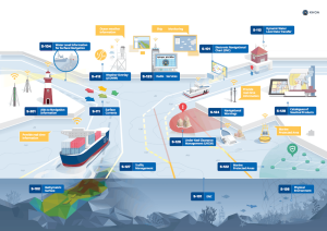
Overview of selected S-100 product specifications and their application domains. Source: IHO
The Transition from S-57 to S-100
The transition to S-100 is an important stage in the wider digital transformation of maritime navigation. However, it is not simply a matter of replacing one chart format with another.
Realising the framework’s potential requires coordinated progress across product specifications, data production, distribution services and onboard equipment. Navigation systems must support the relevant S-100 products, while hydrographic offices and service providers need the processes and infrastructure required to produce and deliver compliant data.
During this transition, existing S-57-based ENCs remain important. Their continued availability, alongside the gradual introduction of S-100 products, helps support operational continuity as the industry moves towards the next generation of electronic navigation.
International coordination is equally essential. Common specifications and consistent implementation practices allow maritime data produced by different countries to be used within compatible systems, helping reduce fragmentation across the digital maritime environment.
Building a More Connected Maritime Information Environment
As maritime operations become more data-driven, the ability to integrate reliable information from multiple sources is becoming increasingly valuable. S-100 provides a foundation for this evolution by establishing common rules for developing, exchanging and using digital hydrographic products.
Its long-term significance extends beyond electronic charts. By enabling a broader range of interoperable maritime information, the framework creates opportunities for more integrated navigation systems, improved operational awareness and new geospatial applications across the marine domain.
For the maritime industry, the challenge ahead is to translate this common framework into practical, reliable services. Continued collaboration among hydrographic offices, standards organisations, technology developers and maritime stakeholders will be essential to realising the full potential of S-100.
The future of digital navigation will depend not only on how much maritime data is available, but also on how effectively that information can be connected, understood and applied. S-100 provides an important foundation for making that future possible.
References
- International Hydrographic Organization (IHO). S-100 Project – The Universal Hydrographic Data Model. https://iho.int/en/s100-project
- International Hydrographic Organization (IHO). S-100 Based Product Specifications. https://iho.int/en/s-100-based-product-specifications
- National Oceanic and Atmospheric Administration (NOAA). The Universal Hydrographic Data Model – S-100 Data Formats. https://marinenavigation.noaa.gov/s100.html
- International Hydrographic Organization (IHO). S-100 Implementation Strategy. https://iho.int/en/s-100-implementation-strategy-0
- PRIMAR. S-100: A Quick Guide.